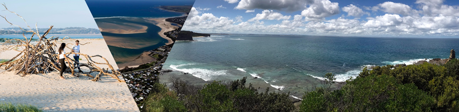
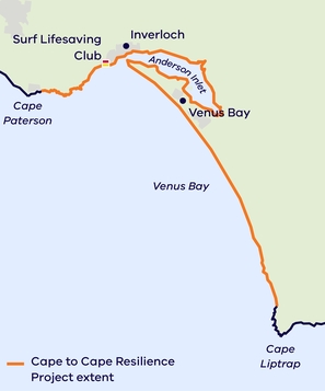
We are building coastal resilience from Cape Paterson to Cape Liptrap.
The coastline around Inverloch, Venus Bay and Anderson Inlet is a beautiful and dynamic part of the landscape. Natural processes such as winds, waves, tides, currents and catchment flows move sand and sediments, reshaping the coastline. These processes sometimes impact places we value, and the way we use the coast.
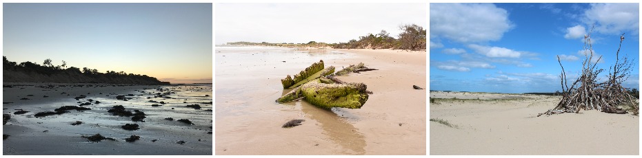
The coastline at and around Inverloch has experienced significant erosion in recent years. Public assets, values and infrastructure are now at risk of damage and loss.
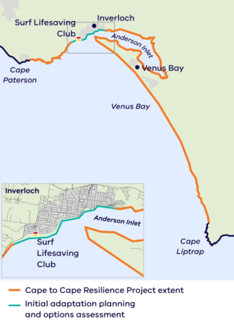
To proactively plan for managing future changes to the coastline, we’re delivering the Cape to Cape Resilience Project. This project combines the latest science, technical assessments and community aspirations to develop a long-term plan to manage important places, assets and other values in the future. The Cape to Cape Resilience Project study area is between Cape Paterson and Cape Liptrap.
This project is being undertaken in two key stages, you can find out more about each Stage below.
Many agencies are responsible for managing coastal and marine areas. A Regional and Strategic Partnership (RaSP) brings these agencies together to respond to key issues. The Inverloch RaSP is the first RaSP established under the Marine and Coastal Act 2018. It has ten partners – Traditional Owners, the Bunurong Land Council Aboriginal Corporation, and nine agencies responsible for managing the Inverloch region's coastal land, assets and infrastructure.
The Inverloch RaSP will work with the community to address ongoing and future coastal erosion and inundation impacts. This includes delivering the Cape to Cape Resilience Project.
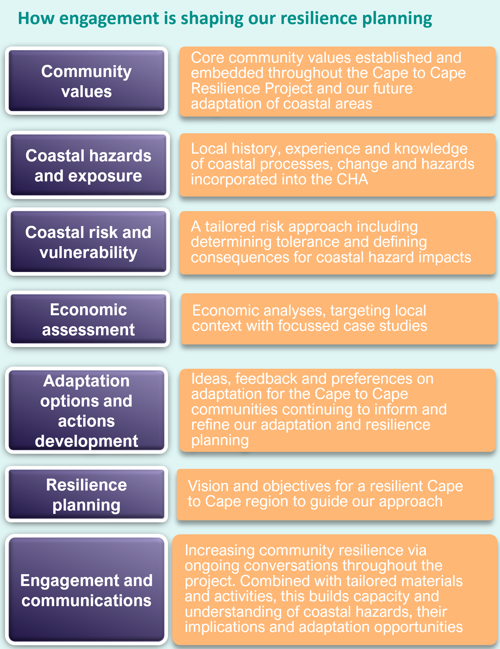
From 2021 to 2022, we delivered Stage 1 of the Cape to Cape Resilience Project. This extensive scope of work produced various technical, strategic and engagement assessments. The outcomes of this work have allowed us to better understand the region’s coastal hazards and possible implications for our local communities, now and into the future. This work included:
More information about these outcomes can be found below.
The Inverloch Region Coastal Hazard Assessment (CHA) is a core technical investigation undertaken in the Cape to Cape Resilience Project. Informed by extensive analyses of the region's geological formation, local conditions, and historical and recent changes along the Cape to Cape coastline, the project team developed various computer models to simulate conditions of the local coastal, estuarine and catchment areas.
These models assessed:
The models have been used to examine how the coastline might change and respond by looking at both present day conditions and predicted future changes, such as rising sea levels and changing wind and wave climates.
This assessment's outcomes help us better understand some of the complex processes impacting our coastline and surrounding areas. As a result, we can now identify areas and assets that may be vulnerable to coastal hazards and changing climate conditions. This knowledge helps to inform the development of possible management or adaptation responses.
For more information about the CHA, check out these two presentations:
Estimated as 'coastal hazard extents', mapping the CHA modelling results indicates areas along the Cape to Cape coastlines that may be exposed to inundation (flooding), erosion (sand loss) or sea level rise.
Many maps have been produced by the project team, showing combinations of the different hazard types, storm events and timeframes. This helps to highlight how hazards and exposure varies for each hazard type, storm events, climate conditions and over different timeframes. This spatial understanding informs our understanding of exposure, vulnerability and risk.
You can view the hazard maps below. Be sure to read the Hazard Map Information Sheet for more information about the maps and how they help us to plan for the future.
The Community Values Study is a key initial study for the Cape to Cape Resilience Project. It provides a basis for better understanding the community’s values, priorities and perspectives in the context of adaptation and resilience planning for the coastal areas of the Cape to Cape region
Data that informed the Community Values Study came from an extensive engagement process between July and September 2021.
You can find the full details of this engagement in our Community Values Study, or a snapshot of the findings below:
Values and Experiences Survey (Snapshot) October 2021 (Word)/(PDF)
Community Values Study December 2021 (Word)/(PDF)
Community Engagement: Adaptation Survey Outcomes (Snapshot) April 2022 (Word)/(PDF)
Read the full suite of technical and strategic reports from Stage 1 below:
We have also created summaries of the key reports to help communicate the key work and findings of the project:
We are now working through the final components of Stage 2, the development of the Cape to Cape Resilience Plan.
Formed over two years, agencies, stakeholders and communities collaborated to create the plan, which provides a roadmap to build resilience across communities and adapt to coastal hazards both now and into the future.
The draft Cape to Cape Resilience Plan includes:
The draft Resilience Plan is available for public comment through a formal 28-day public consultation period beginning Friday 23 August 2024. More information below.
We are seeking community feedback on the draft Resilience Plan through a 28-day public consultation period beginning Friday 23 August 2024. Feedback will be collected via an online survey or uploading a submission to our Engage Victoria page.
Submissions on the draft Cape to Cape Resilience Plan may be made to DEECA via Engage Victoria on or before Sunday 22 September 2024.
This feedback will assist us in refining the final Cape to Cape Resilience Plan.
Check out our short explainer video for some extra context when reading and understanding the plan.
Adaptation can be defined as 'the process of adjustment to actual or expected climate and its effects’.
A range of actions can be considered for mitigating coastal hazard risk and adapting to climate change. These may include activities associated with planning, capacity building, engineering, or other themes.
In considering options to mitigate coastal hazard risk, the Victorian Marine and Coastal Policy (2020) provides direction to respect natural coastal processes, apply an adaptation pathways approach, and consider options in the following order:
More information about the approach to adaptation and these options can be found in Factsheet #6 Strategic Approach to Adaptation and Factsheet #7 Adaptation Action.
Static visualisations of engineering adaptation options, as identified within the Adaptation Action Technical Assessment of the Inverloch Region Coastal Hazard Assessment. The below photo montages are based on conceptual designs proposed within the report, presenting visual aesthetic impacts the adaptation options would have on the coastal environment. *Noting that detailed designs have not yet been developed.
Large scale beach nourishment Bunurong Road (JPG)/(PDF)
Rock seawall Bunurong Road (JPG)/(PDF)
Geotextile sandbag seawall Bunurong Road (JPG)/(PDF)
Large scale beach nourishment Inverloch Surf Beach - aerial view (JPG)/(PDF)
Large scale beach nourishment Inverloch Surf Beach - beach level/oblique view (JPG)/(PDF)
Rock groynes and nourishment Inverloch Surf Beach - aerial view (JPG)/(PDF)
Rock groynes and nourishment Inverloch Surf Beach - beach level/oblique view (JPG)/(PDF)
Geotextile sandbag groynes and nourishment Inverloch Surf Beach - aerial view (JPG)/(PDF)
Geotextile sandbag groynes and nourishment Inverloch Surf Beach - beach level/oblique view (JPG)/(PDF)
Long rock groyne Point Norman Inverloch Surf Beach - aerial view (JPG)/(PDF)
Long rock groyne Point Norman Inverloch Surf Beach - beach level/oblique view (JPG)/(PDF)
Nearshore rock breakwaters Inverloch Surf Beach (JPG)/(PDF)
Speaking with our community is key to the Cape to Cape Resilience Project. Our stakeholder and community engagement is happening throughout the project and will be tailored to align with and inform key elements of the technical work.
As our project team continues with our adaptation and resilience planning, we will also continue talking to our key stakeholders and community.
Our work to date has already explored a range of topics relating to coastal hazards and their management with our community:
Hearing ideas and perspectives from the Cape to Cape communities remains an important part of this project and will help shape the region's adaptation pathways and actions.
Extensive and targeted community and stakeholder engagement was completed throughout Stage 2, to help inform our Resilience Plan. Visit our Engage Victoria page for the latest information on how you can participate.
The Cape to Cape Resilience Project is a coastal hazard adaptation project, overseen by the Inverloch RaSP. The project includes:
In response to erosion experienced along the Inverloch foreshore, coastal hazard adaptation options will initially focus on the 5 km coastline from Flat Rocks to Screw Creek.
Working with the RaSP agencies, the project team will consider a range of adaptation options for this stretch of coastline. The Inverloch Coastal Hazard Assessment, risk assessments, and community values and adaptation preferences will inform the development of possible options.
Using tailored objectives and criteria, we will shortlist options to examine further. Criteria will include community values, environmental impacts, costs, performance and effectiveness, and amenity (including impacts on access and aesthetics). Importantly, the order of consideration for options must also align with the directions for managing coastal hazard risk outlined in the Victorian Marine and Coastal Policy (2020).
A detailed analysis of the shortlisted options will draw on modelling, economics, and strategic planning to determine actions for Flat Rocks to Screw Creek and inform adaptation planning for the broader Cape to Cape coastline and communities.
Computer models will test the performance and suitability of different adaptation options (interventions) under different scenarios. Up to 5 adaptation interventions will be modelled to determine their effectiveness in mitigating hazard risk and considering potential impacts on surrounding areas.
We will assess options for present-day and future conditions to ensure they are appropriate now and how long they will be effective. Short, medium and long term actions can then be included in the adaptation planning process.
While we plan, develop and design adaptation solutions, the Inverloch Coastal Protection Interagency Working Group continues actively monitoring the coastline to determine if further short-term, rapid response/management measures are required.
The project provides many different and exciting opportunities for the community and stakeholders to be involved.
Using a range of in-person and online activities and events, we will be looking to share key information from the project. We are also keen to gather your insights into what you value about the coast from Cape Paterson to Cape Liptrap, and your perspectives on adaptation and resilience.
We will be providing regular updates and factsheets to keep you informed about the project.
The study area for the Cape to Cape Resilience Project is between Cape Paterson and Cape Liptrap on the Bass Coast, Gippsland.
The area of interest includes:
There will be a range of project outputs, including:
The expected outcomes of the Cape to Cape Resilience Project include:
Natural coastal processes like wind, waves, tides and currents work to shift sediment and shape the coastline. When these processes negatively impact on use of the coast, they become coastal hazards. These impacts could be environmental, social, cultural or economic impacts. Coastal hazards include coastal erosion and inundation.
The Coastal Hazard Assessment will consider:
This new research will:
We’ll also look at different magnitudes of coastal storm events and potential changes in wind and wave direction.
Water Technology will undertake the Coastal Hazard Assessment and technical investigations.
The South Gippsland Conservation Society has been working on the Inverloch Coastal Resilience Project (ICRP) since 2018.
The project aims to:
In August 2019 the first significant output of this project was produced: the Inverloch Coastal Resilience Project Report (August 2019). The SGCS is continuing to work in collaboration with the Victorian Coastal Monitoring Program, DEECA, Bass Coast Shire Council and Parks Victoria for its project. More information about the
The Inverloch Coastal Protection Interagency Working Group actively monitor the coastline and the condition of recent coastal protection works. If further short-term protection is necessary, the working group will decide together and seek funding for implementation.
Resilience is the capacity of systems to cope with or 'bounce back' following a hazardous event or disturbance. This includes social, economic and environmental systems. Resilience means responding or reorganising to maintain essential functions, identities and structures, while maintaining the capacity to adapt and transform.
Adaptation is defined by the Intergovernmental Panel on Climate Change (IPCC) as ‘the process of adjustment to actual or expected climate and its effects’. The definition differentiates between human and natural systems. In human systems, adaptation seeks to moderate or avoid harm or exploit beneficial opportunities. In some natural systems, human intervention may facilitate adjustment.
Regional and Strategic Partnerships (RaSP) are a new tool under the Marine and Coastal Act 2018. RaSPs bring stakeholders together on regionally significant issues. The Inverloch RaSP is the first created under the new Act, gazetted on 6 August 2020.
The RaSP brings together Traditional Owners and nine agencies. They each have a role in managing coastal and foreshore values, assets and infrastructure around Inverloch. They commit to working together to respond to coastal hazards facing the Inverloch community now and into the future.
The Inverloch RaSP has representatives from the following agencies and entities:
The Stakeholder Reference Group (SRG) is an independent group that supported Stage 1 of the Cape to Cape Resilience Project. The group included invited stakeholders and community members selected through expressions of interest.
The Inverloch Coastal Protection Interagency Working Group is separate to the RaSP. The Interagency Working Group consists of representatives from:
The group focuses on addressing current erosion at Inverloch and developing a short-term erosion control plan for key areas around Inverloch. The RaSP will focus on longer-term adaptation over the wider Cape Paterson to Cape Liptrap coastal area.
Wreck Creek is a small intermittently closing and opening coastal lagoon located on the western edge of Inverloch. The lagoon is separated from the ocean by a sandy beach berm that forms and breaks down depending on the redistribution of sand and sediments by waves, tides, flood flows and winds. For questions related to the management of Wreck Creek, please read the frequently asked questions available in Word and PDF.
Page last updated: 10/09/24